 Wetland Inventory & Map Project
Wetlands play a critical role in our lives. They sequester carbon, produce oxygen and distill water in controlling pollution. Wetlands are an important habitat and provide a variety of food sources for animals including mammals like people. Have you ever enjoyed cranberries, crab cakes, shrimp, or wild rice? They all come from wetlands. Wetlands add aesthetic value to property. Because they are so attractive to wildlife, wetlands can be outstanding recreation sites for those who enjoy watching or harvesting wildlife. Scientists are showing us that wetlands play a critical role in cleaning, recovering and controlling fresh water. They serve as landmarks and historic reminders.
Watch New York Times video - Unearthing Pennsylvania's Streams - discover the power of an old map as a tool for science.
Your community has decided to inventory all their wetlands . (Wetland Mapping and Classification of the Kenai Lowland, Alaska) The goal is to create a map and a database with all the information collected for each unique wetland. This information will be used to make decisions regarding development. You will be participating by collecting data. Functions and Values of Wetlands
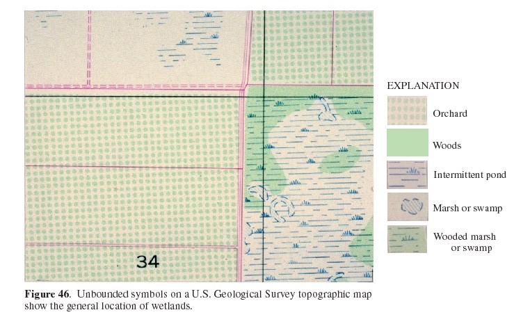
Begin by reviewing the many resources at Identifying Wetlands. and Chapter 2: Classification of Wetlands
1. Select an area to inventory. This could be your school's campus, a local public park or a neighborhood.
Respect property rights. Do not enter private property without permission.
2. Make a rough map of the area you will be mapping that includes major structures, streets and major waterways. If there is a locally available map of your community, you could use it. (Sometimes the local Chamber of Commerce, visitors agency or realtors have free local maps.)
3. Review how to classify wetlands
Wetlands and Deepwater Habitats Classification Hierarchy pdf
Wetland Definitions and Classifications in the United States
4. Data to consider collecting:
(make a paper form or a spreadsheet/database with the data to be collected so that each wetland is on a separate form or ss row or db record.)
Location - use GPS if possible, use street address if it is not.
Process:
Divide the site into sub areas with two or 3 people working in each sub area.
Assemble your tools. What will you need?
Collect the data. How will you avoid counting wetlands more than once?
Publish your findings.
Resources:
View Wetlands Data with Google Earth | On this website: GIS - Using and Understanding
A Week in the Life of the NatureMapping Program | Create/Print a local bird list
PLANTS - USDA website | Environmental Concern - we are about wetlands
Wetlands EcoStudy Unit | Schoolyard Wetland Habitats | Wetland 101: Online Course and Quiz
Green Maps Around the World | Mapping out a new world order CNN
Geographic Resources Analysis Support System, commonly referred to as GRASS GIS, is a Geographic Information System (GIS) used for data management, image processing, graphics production, spatial modeling, and visualization of many types of data. It is Free Software/Open Source released under GNU General Public License (GPL). GRASS is official project of the Open Source Geospatial Foundation.
Critter Quest PA explore natural diversity using gis mapping
Pathfinder Science - "hands-on, minds-on" activities (student scientists not just science students)
Capturing Carbon - Nova Science Now online video Jul. 2008
An eighth-grader's science fair project prompts her scientist father to develop a new way to pull excess carbon dioxide out of the atmosphere.
"The nation behaves well if it treats the natural resources as assets which it must turn over
to the next generation increased and not impaired in value." Theodore Roosevelt (The New Nationalism, 1910)
Internet
Hunts / Nature / Mapping trees in your community / Plants
and People / Puzzles & Projects / PA. Projects / Home
All trademarks, copyright and logos belong to their respective owners.
2008
Cynthia J. O'Hora dedicated to honor Dr. Wangari Maathai
Released for use by nonprofit organizations posted
5/2008